
 Inquiry
Solution
Optimization of urban drainage system
1. Background Analysis
According to the Ministry of Water Resources16>, the Ministry of Water Resources and the National Development and Reform Commission recently officially issued the "Implementation Plan for Major Agricultural Water-saving and Water-supply Projects in the '14th Five-Year Plan' Period", clearly prioritizing the implementation of 30 new large-scale irrigation districts and 124 existing large-scale irrigation districts for modernization transformation, which are included in the 150 major water conservancy projects determined by the State Council. Central budgetary investment will actively support, while requiring local governments to coordinate and increase financial support, innovate the investment and financing system and mechanisms, and raise funds from multiple channels to ensure timely and sufficient construction funds. It is expected that after the implementation of the plan, the new large-scale irrigation districts can add 15 million mu of effective irrigation area and improve 9.8 million mu of irrigation area.
The "14th Five-Year Plan" for major agricultural water-saving and water-supply projects proposes the construction of informationization in irrigation areas, which is the most important part of the construction content of irrigation areas!
2. Construction Content
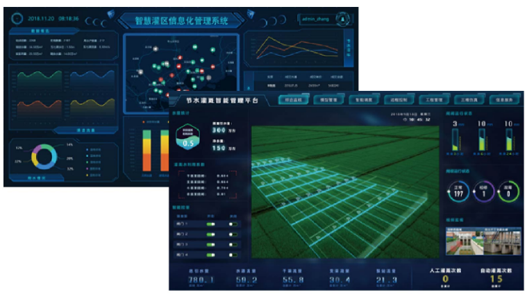
Manage cloud platform
Construction of informationization in irrigation areas, focusing on the existing water resources, water ecology and water disasters in irrigation areas, to achieve intelligent perception, automatic control, intelligent monitoring, intelligent management, and further improve the modernization management level of irrigation areas, and promote the development of modern agriculture in irrigation areas.
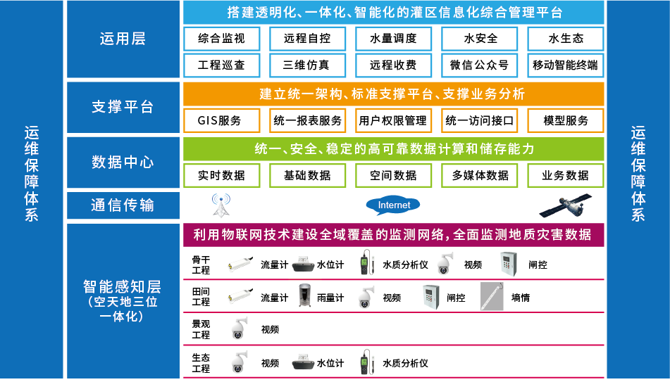
Smart perception system construction
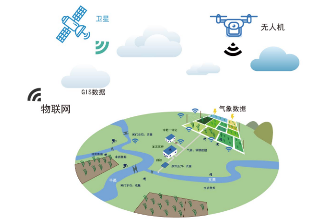
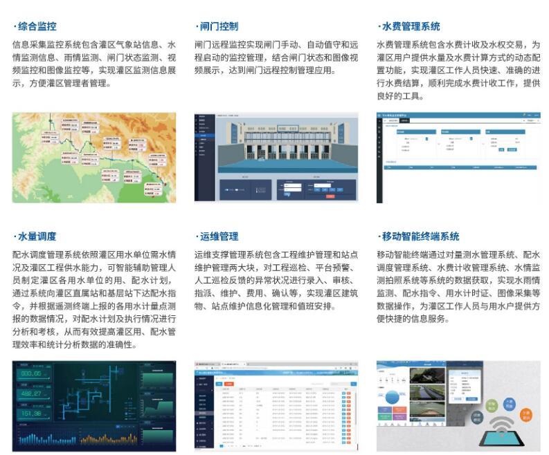
The construction of smart perception network mainly focuses on the Internet of Things perception, aerial perception and video perception. It mainly includes the information needed for rain situation, water situation, project situation, soil moisture situation, water quality, engineering safety monitoring, and the smart water management system. The layout of information collection should cover the whole process of information flow and form a closed loop, and the Internet of Things perception network covering the whole area should be built.
Communication network construction
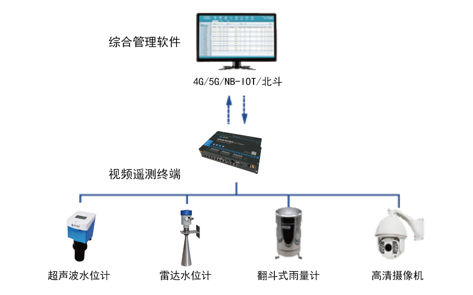
To ensure the real-time monitoring capability and data transmission efficiency of the entire canal system project in the irrigation area, and to support the normal collection and transmission of flood control, water environmental protection, and water resources allocation information in the canal system, it is necessary to build an efficient and stable transmission network. The data collected from each monitoring point in the communication scheme of the irrigation area project is transmitted to the data backup center bythe "dual-deployment" mode of flexible wired and wireless deployment, realizing the local storage + cloud storage function of information disaster recovery instruments.

Data center construction
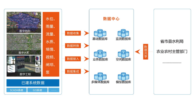
The irrigation area information management system takes data sharing and business collaboration as the fundamental starting point, through data collection, sorting, data access, and gathering(data standardization processing, standard interface customization), integrate and reconstruct various water conservancy information resources, establish an interconnected and intelligent integrated data center, and achieve centralized data collection, centralized storage, centralized management, and centralized use.
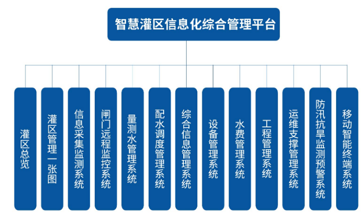
Integrated management platform
With the core focus on improving water use efficiency and the guarantee of a strict water resources management system, the system monitors and analyzes data, and accurately calculates to provide a scientific data foundation for water volume scheduling, precision irrigation, and water rights trading. At the same time, the irrigation conditions of each irrigation area and different districts and counties are included in the irrigation area information management platform, providing comprehensive monitoring, decision analysis and other services, to provide scientific control basis for the management of irrigation areas, and to promote the comprehensive construction of the information management of irrigation areas.
Smart Irrigation District Map
Irrigation District Management"One Map" is based on the GIS map of the irrigation district, aggregating basic topographic maps, administrative area maps, land use status maps, basic farmland protection maps, water system distribution maps, flood control project distribution maps, irrigation project distribution maps, irrigation area distribution maps, water and rain engineering situation monitoring distribution maps, water resources red line maps, remote sensing image maps, and other multi-source information maps, superimposed on the irrigation district's water resources and engineering management and other business management systems, to construct a unified "underground measurement, online control, platform management" irrigation district comprehensive supervision "one map".
System application
Water metering monitoring system
The water gauge monitoring station has realized the automatic real-time monitoring of water level and flow rate for the whole process of water diversion, water transmission, water distribution, water division points and boundary points, providing data support for the overall dispatching of the irrigation area and sub-centres, and realizing the optimization of water resources allocation.
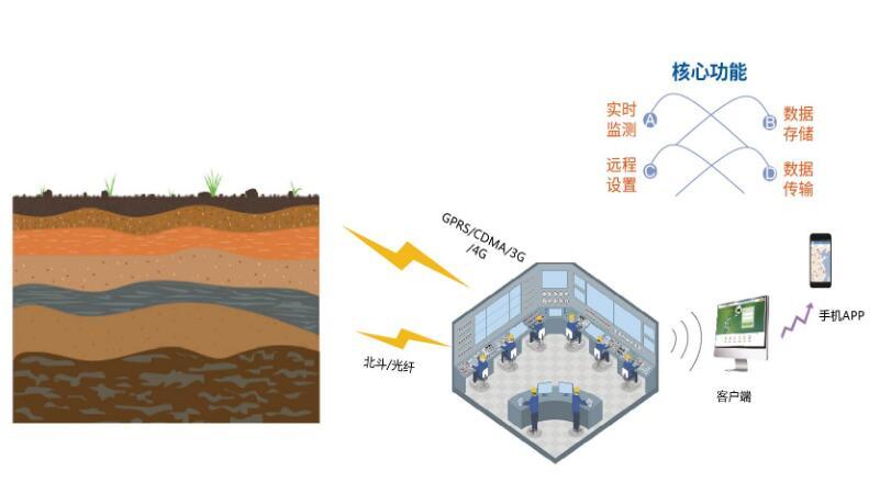
Hydrological monitoring system
The hydrological and meteorological monitoring station is mainly used to remotely and automatically collect and capture the entire process of water and rain conditions, and to record the dynamic changes of river, reservoir and channel water levels in real time. By analyzing the hydrological and meteorological data monitored, it provides auxiliary decision-making basis for the assessment of water demand and water supply in the irrigation area, and achieves the scientific allocation of water resources.
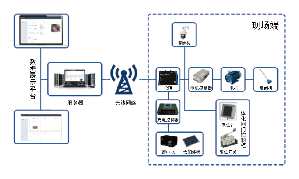
Gate control system
The gate monitoring station remotely controls and manages the changes in the water inlet gate of the canal, the gate of the sluice gate or the gate of the key branch canal and the source of water. According to the instructions issued by the system, the target flow or water level is transmitted to the gate controller, the opening of the gate is regulated, and the flow or water level of the canal is brought to the target value. Reduce the amount of manual labor, the error rate of subjective water release control can reach the precise control of the gate, can timely grasp the operation information of the irrigation area, provide the basis for the optimization allocation of water resources, reduce the waste of water resources, and promote the improvement of the comprehensive benefits of the irrigation area.
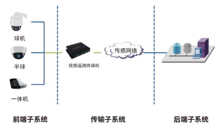
Video surveillance system
The video surveillance station can accurately, clearly and quickly transmit real-time video and data information from the surveillance site to the management center. The management center can understand and master the actual situation of the surveillance site in real time through the video surveillance system. At the same time, the center staff respond and deal with the situation according to the situation of the surveillance site, so as to effectively manage the operation of the water conservancy facilities and the surrounding site situation.
Soil monitoring system
Soil moisture monitoring stations are the basic work for studying the rules of the water cycle, agricultural and pastoral irrigation, rational use of water resources, and collecting basic information for drought resistance and disaster relief. Soil moisture information mainly monitors soil moisture content and soil temperature, providing decision-making basis for the informatization system of the irrigation area.
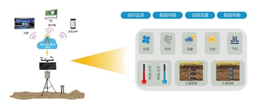
Weather monitoring system
The agricultural meteorological station mainly monitors the meteorological elements such as temperature, atmospheric pressure, relative humidity, wind direction, wind speed, rainfall, light, soil temperature and humidity in the irrigation area, to achieve all-weather monitoring of the small climate of the farmland in the irrigation area. Provide systematic data support for the information platform of the irrigation area.
Three, typical applications
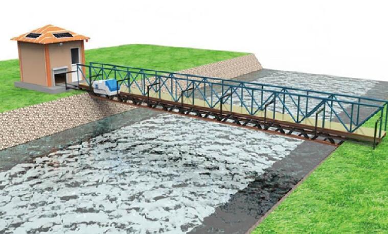
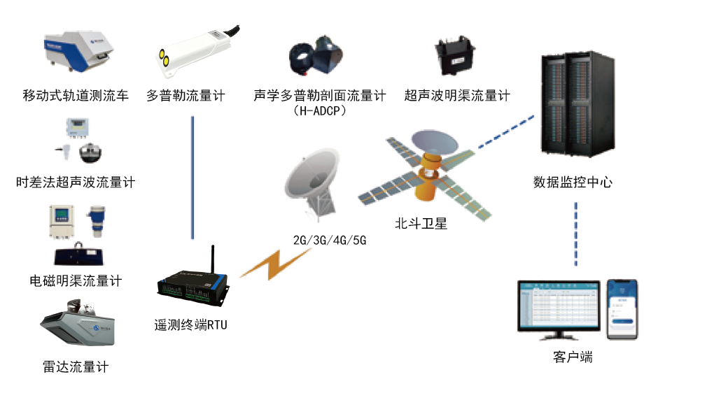
Main canal track vehicle automatic flow measuring system
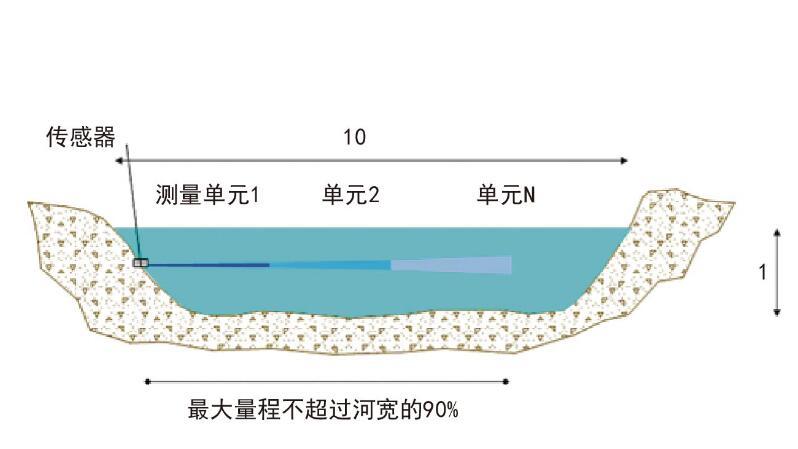
Main CanalH-ADCP Automatic Flow Measurement System
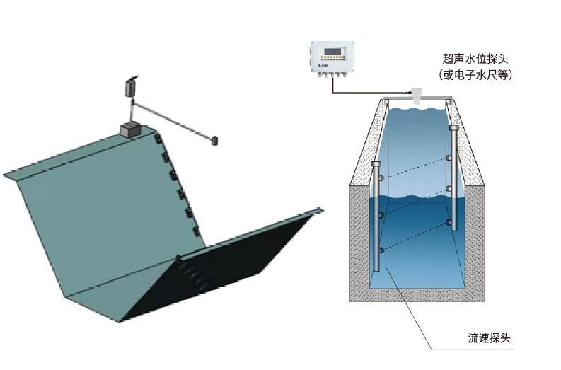
Channel Ultrasonic Time-of-Flight Flow Measurement System
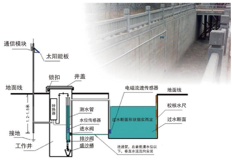
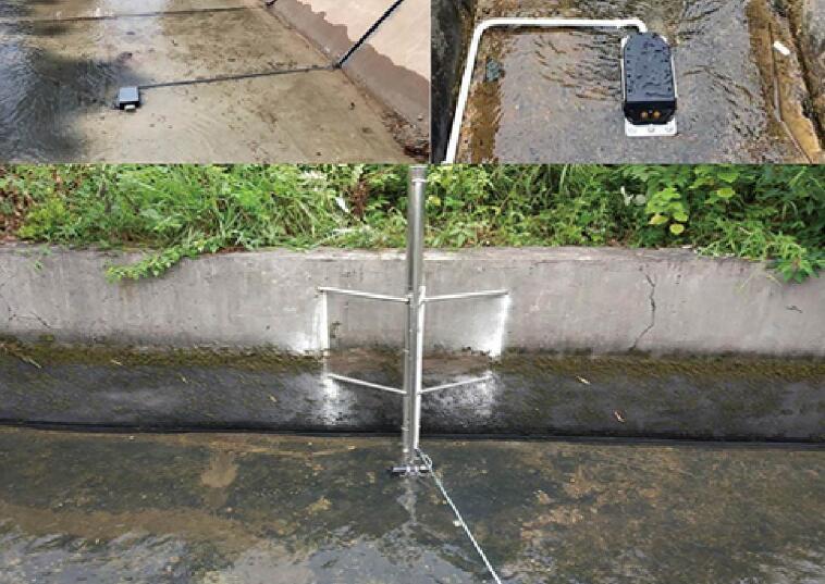
branch channel electromagnetic open channel flow monitoring system
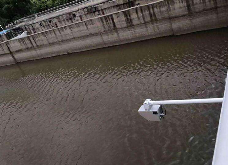
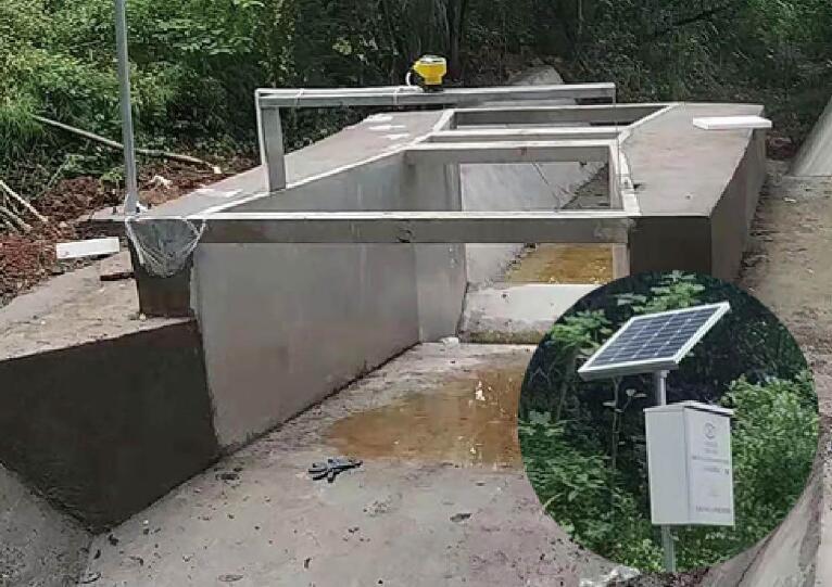
Radar flow measurement system
Doppler flow metering system
Ditch dyke measuring system
IV. System Characteristics
◆ Building a unified "underground monitoring, online control, and platform management" comprehensive supervision "map" for the irrigation area.
◆ Realize dynamic planning of water use, optimize the allocation of water resources, timely and moderate irrigation and drainage, meet the needs of modern production in the irrigation area, and improve economic efficiency.
◆ Scientific irrigation, improve planting level, ensure national food security and effective supply of agricultural products, and achieve sustainable development of the irrigation area.


Copyright © 2025 Xiamen Haichuan Runze Internet of Things Technology Co.,Ltd. ALL Rights Reserve.
Welcome to leave a message for consultation